
Municipality of Dolneni
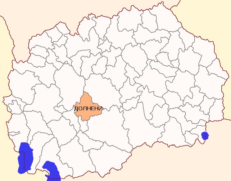
Municipality of Dolneni is located in the northwestern part of the Pelagonia valley, at an altitude of about 600 meters. It was established by the Law on Territorial organization and Law on local government of 1996 and is extended by merger of municipality of Zitiste with the last Law on territorial organization of the Republic of Macedonia since 2004.
Municipality of Dolneni – Comparative advantages
The larger part, which covers 2/3 of the area, is a flat part with mainly farmland (90%), and the second part, which occupies 1/3 of the total area is hilly and mountainous part of which the half is covered with pastures and the other half in wood (oak, beech, ash, etc.).
The plains of municipality of Dolneni have a large stock of arable land used for multiple purposes in the agricultural production, while on the smaller part natural pastures and meadows are developed. In northern part the relief is mountainous, mostly with mild slopes (except in the highest parts) cut by larger number of river valleys that descend to Pelagonia.
The highest peaks Gol Rid, Kodrostan and Luta reach from 1,500 to 1,700 meters altitude. In this part prevalent the most important natural resources: forests (mainly oak and beech), mountainous and hilly pastures, sources and natural water courses (rivers and streams), diverse wildlife and ore deposits of quality marble.
Municipality of Dolneni consists of 35 settlements, where according to the 2002 census, 13.568 people live.
The social structure of the population indicates a distinctively agricultural municipality, because half of the working population is farmers, while with non-agricultural activities are concerned only 11% of the total population.
Municipality of Dolneni is characterized by the large number of sunny days per year, making it suitable for the production of electricity using solar panels, and a large area of arable land, suitable for the production of organic food. Protected and untouched natural environment is an opportunity for development of eco tourism.
Municipality of Dolneni – Main data
|
MUNICIPALITY OF DOLNENI 7504, Dolneni +389 48 453 210 www.opstinadolneni.gov.mk
|
 |
| Coordinates | * Latitude – 41о42’ N
* Longitude – 21о45’ E |
| Area | * 412,43 km2 |
| Areal codes | * International code: ++389(R. Macedonia)
* National code: 048 * Postal code: 7504 |
| Population | * 13.568 inhabitants (Census 2002)
* 14.033 inhabitants ( Estimated by the State Statistical Office, till 31.12.2014) |
| Gender structure | * Female – 47,67%
* Male – 52,33% |
| Number of unemployed people (ESA, December 2015 ) | * 667 |
| Elementary schools | * OU “Peco Daskalot“ – Dolneni
* OU “Pere Toshev“ – Dupjachani * OU “Vera Ciriviri Trena“ – Debreshte * OU “Lirija“ – Zhitoshte * OU “Mirche Acev“ – Lazani * OU “Gjorche Petrov“ – Ropotovo * OU “Ismail Kemali“ – Crnilishte |
| Secondary schools | * SOU “Prerodba-Rilindia“ – Zhitoshte (gymnasium) |
| Number of active legal entities | * 195 (State Statistical Office, till 31.12.2014) |
| Priority sectors /industries in the Municipality | * Agriculture
* Mining – Mineral Resources (Marble, granite, quartz) |
| Contact information for potential investors | * Boshe Milosheski
Mayor of the Municipality of Dolneni Tel.: 048-453-210 E-mail: [email protected] |
Municipality of Dolneni – Traffic connections
|
TRAFFIC CONNECTIONS
|
|
| Regional roads | · R1303 (Prilep – Kicevo)
· R2335 and R2336 (Krivogastani – Zitose –Lazani –Ropotovo –Crniliste) |
| Distance from airports: | · Alexander the Great (Skopje) – 144 km
· St. Paul the Apostol (Ohrid) – 104 km · Airport Macedonia (Thessaloniki, Greece) – 245 km |
| Distance from harbors: | · Harbor in Burgas, Bulgaria- 710 km
· Harbor in Thessaloniki, Greece – 226 km · Harbor in Durres, Albania – 272 km · Harbor in Bar, Montenegro – 391 km |
| Distance from railroads | · Railway station Skopje – 145 km
· Railway station Sofia – 336 km · Railway station Thessaloniki – 226 km |
| Distance from capital cities: | · Skopje – 145 km
· Sofia – 336 km · Belgrade – 545 km · Podgorica – 392 km · Pristina – 232 km · Athens- 694 km · Tirana – 234 km |
| Distance from border crossings: | · Bulgaria – 220 km
· Serbia – 160 km · Greece – 63 km · Kosovo – 168 km · Albania – 140 km |
Municipality of Dolneni – Investing opportunities
Municipality of Dolneni for the potential investors puts available the industrial zone “Debreste” located near the road Prilep – Kicevo and the regional water supply Studencica. The industrial zone “Debreste” has 154.000 m2 total area and has water and sewage system, electric network, telephony and Internet.
| Industrial zone “Debreste” | |
| Total area | 154.000 m2 |
| Ownership | 100 % state owned |
| Infrastructure | – Electricity
– Water supply – Stormwater drains – Sewerage system – Telephony – Access to construction plots through asphalt / swabbed area |
| Usage of the free locations for construction | G2 – light and non-polluting industry |
| Initial price for the land | 61,00 den./m2 |